Twelve Greenville neighborhoods compared: ZIP code, zoned high school and Zillow's typical home value for each, from the West End to Gower Estates.
Last checked Oct. 16, 2026. Sources: the City of Greenville’s GIS layers (city limits, Central Business District, neighborhood engagement areas, special emphasis neighborhoods, preservation overlays, National Register sites, address points, parks), neighborhood association list and neighborhood plans; Greenville County Schools’ Find Your School; the state’s 2025 school report cards; Zillow Research; the Census Bureau; Greenlink’s published GTFS schedule; and OpenStreetMap.
Greenville is a city of about 72,900 people (Census Bureau, 2020-2024 American Community Survey) laid out around Main Street and Falls Park on the Reedy River. I-385 runs in from the southeast to its exit 42 at Stone Avenue, the closest interstate exit to downtown, and I-85 and I-185 cross the south and southwest sides. Many homes with a Greenville mailing address sit outside city limits, in unincorporated Greenville County. This guide covers 12 areas the city names and maps itself or that OpenStreetMap places, with the schools, home values, parks and commute for each.
Before you choose an address
- City limits are not the mailing address. Greenville ZIP codes reach well beyond city limits into unincorporated Greenville County, where homes pay no city tax and get county services. Check a parcel on the county’s GIS maps.
- School zones do not follow city limits. The whole county is one district, Greenville County Schools, and in five of the 12 areas below the high school zone splits inside the neighborhood. Look up the exact address in Find Your School.
- Historic districts have design rules. Exterior changes in the city’s preservation overlay districts go through the Design Review Board.
The neighborhoods at a glance
Home values are the Zillow Home Value Index for each area’s ZIP codes in September 2026, a modeled typical value for the middle third of homes, not a sale price. Zones are from 40 addresses per area checked in Find Your School for 2026-27.
| Area | ZIP | Zoned high school | Typical value (ZIP) | Guide |
|---|---|---|---|---|
| Downtown | 29601 | Greenville Senior High | $571,299 | Downtown |
| Hampton-Pinckney | 29601 | Greenville Senior High (82%); Berea (18%) | $571,299 | Hampton-Pinckney |
| East Park | 29601 | Greenville Senior High | $571,299 | East Park |
| North Main | 29609, 29601 | Greenville Senior High | $352,947; $571,299 | North Main |
| West End | 29601, 29611 | Greenville Senior High | $571,299; $213,642 | West End |
| Southernside | 29601 | Greenville Senior High (51%); Berea (49%) | $571,299 | Southernside |
| West Greenville | 29611, 29601 | Berea | $213,642; $571,299 | West Greenville |
| Overbrook | 29607 | Greenville Senior High, Eastside or Wade Hampton | $385,351 | Overbrook |
| Nicholtown | 29607 | Wade Hampton or J.L. Mann | $385,351 | Nicholtown |
| Alta Vista | 29601, 29605 | Greenville Senior High (82%); J.L. Mann (18%) | $571,299; $298,298 | Alta Vista |
| Gower Estates | 29607 | J.L. Mann | $385,351 | Gower Estates |
| Pleasant Valley | 29605 | Southside | $298,298 | Pleasant Valley |
On the 2025 state report cards, Greenville Senior High Academy, J.L. Mann, Wade Hampton and Eastside were rated Excellent, and Berea and Southside were rated Average. The citywide Zillow figure was $328,460, up 1.62% on the year, and 29615, on the east side, was $438,763. More in our home prices guide and schools guide.
Map
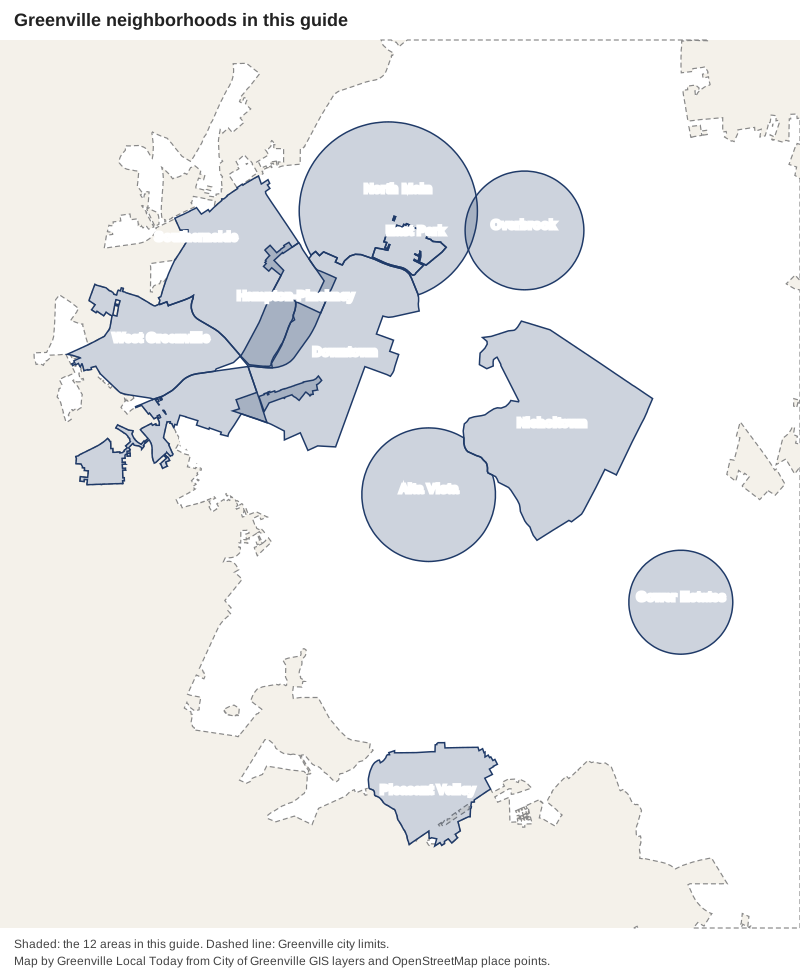
Map: Greenville Local Today, from the City of Greenville’s GIS layers (city limits, Central Business District, neighborhood engagement areas, special emphasis neighborhoods, preservation overlays) and OpenStreetMap place points, © OpenStreetMap contributors.
The areas
Downtown. Main Street, Falls Park and the blocks around them, inside the city’s Central Business District boundary: about 3,500 residential addresses, almost all apartments and condos. Every Greenlink route starts at the transit center on West McBee Avenue. Downtown guide
Hampton-Pinckney. One of the city’s oldest residential neighborhoods, a National Register historic district and city preservation district northwest of downtown, next to Unity Park. Hampton-Pinckney guide
East Park. A small historic district of about 185 homes by McPherson Park, north of downtown, zoned for Stone Academy, League Academy and Greenville Senior High. East Park guide
North Main. The area along North Main Street toward Stone Lake, with about 2,200 homes, the Colonel Elias Earle Historic District and North Main Rotary Park. North Main guide
West End. The blocks south and west of downtown by Falls Park, with the West End Commercial Historic District at its core and about 1,150 homes, mostly apartments and condos. West End guide
Southernside. Northwest of downtown along West Washington Street, around Unity Park and the Amtrak station, with a city neighborhood plan. Its high school zone splits almost evenly. Southernside guide
West Greenville. The Pendleton Street area west of the Reedy River, about 1,300 homes, mostly in ZIP 29611 and zoned for Berea High. West Greenville guide
Overbrook. A mostly single-family area northeast of downtown along East North Street, with a city preservation overlay, the National Register house Isaqueena and four city parks. Overbrook guide
Nicholtown. About 2,150 homes east of downtown, with the Nicholtown Community Center and Sliding Rock Creek Park, split among several school zones. Nicholtown guide
Alta Vista. Mostly single-family houses south of downtown between Augusta Street and Cleveland Park, with Watts Park and the Swamp Rabbit Trail. Alta Vista guide
Gower Estates. About 350 single-family houses southeast of downtown, all zoned for Sara Collins Elementary, Beck International Academy and J.L. Mann. Gower Estates guide
Pleasant Valley. About 730 homes on the south side near I-85 exit 46, zoned for Southside High, with a city neighborhood plan. Pleasant Valley guide
Compare Greenville with its neighbors
Taxes, schools, home values and services in the city, Mauldin, Simpsonville and Travelers Rest, side by side: Greenville vs. Mauldin vs. Simpsonville vs. Travelers Rest.
How we built this
- Which areas: only places the City of Greenville maps itself or OpenStreetMap names as a place. Downtown is the city’s Central Business District layer; Hampton-Pinckney and the West End are its neighborhood engagement areas; Nicholtown, Southernside, West Greenville and Pleasant Valley are its special emphasis neighborhoods, each with a city neighborhood plan; East Park is its preservation overlay and National Register district. North Main, Overbrook, Alta Vista and Gower Estates have no city boundary, so we used the OpenStreetMap place point and a radius inside city limits; each also has an association on the city’s list.
- Left out: smaller city-mapped areas such as Sterling, Haynie-Sirrine, Greenline-Spartanburg, Viola, Green Avenue, Stratham Place and Logan Park, the parts of the city along Woodruff Road and Haywood Road with no city or OpenStreetMap neighborhood name, and individual subdivisions. We found no city or county HOA registry.
- Schools: 40 residential addresses per area from the city’s address file, looked up in Greenville County Schools’ Find Your School tool on Oct. 16, 2026.
- Everything else: Zillow Research for home values, the state’s report card data for ratings, the city’s GIS and park pages for parks, Greenlink’s schedule data for bus routes, and OpenStreetMap for stores, interstate exits and road distances.
More: moving to Greenville, property taxes and getting around.
Frequently asked questions
What are the neighborhoods in Greenville, South Carolina?
The city maps neighborhoods in its GIS layers, including Hampton-Pinckney, the West End, Southernside, West Greenville, Nicholtown, Pleasant Valley and East Park, and lists dozens of neighborhood associations by name, including North Main, Overbrook, Alta Vista and Gower Estates. This guide has a page for 12 areas.
What school district is the city of Greenville in?
Greenville County Schools, the single district for the whole county. Its attendance zones do not follow city limits, and several neighborhoods are split between high school zones, so check an address with the district’s Find Your School tool.
What ZIP codes are in the city of Greenville?
Six cover almost all of the city’s residential addresses: 29607 (about 42%), 29601 (22%), 29605 (12%), 29615 (10%), 29609 (9%) and 29611 (4%), according to the city’s address file.
Which Greenville neighborhoods are historic districts?
Hampton-Pinckney, East Park, Colonel Elias Earle in North Main, Overbrook, Pettigru Street and the West End are among the city’s preservation overlay districts, where exterior changes go through design review.
What is the typical home value in Greenville?
$328,460 citywide in September 2026, up 1.62% on the year, according to the Zillow Home Value Index. By ZIP code it ran from $213,642 in 29611 to $571,299 in 29601.
Have your say